Healthcare
Tracking public health across neighborhoods, regions, and countries has become a prime agenda of government authorities, the collective United Nations, and the World Health Organization. Together, they track and improve both the public's access to and the quality of care received. Once problem areas are identified health professionals are tasked with planning targeted improvements. Recently, GIS and Remote Sensing have advanced healthcare improvements by identifying population health needs, protecting hospitals and clinics from location risks, and providing data to improve existing healthcare services.
Targeting Locations for New Healthcare Facilities
GIS' spatial data is especially useful for expanding and rebuilding communities. Discovering untapped healthcare service ares requires knowing what kind of people your facilities could service, where these people live, and how they transport themselves. Most within the healthcare industry agree every neighborhood should have access to a basic clinic and pharmacy, with the ability to transport patients to larger hospital facilities if the need arises. Therefore, communities around the world use GIS to assess their healthcare services and how people are using them.
In 2013 Kigali, the capital city of Rwanda, most people were walking as their main mode of transport. In that region, people who walk are often from the poorest areas and can therefore be considered a vulnerable population when their healthcare is limited to far away clinics. If even a basic clinic is an hour's walk, this is a significant disadvantage for pregnant mothers or the elderly who may need the most frequent medical attention. The below analysis was completed on data collected by the University of Twente.
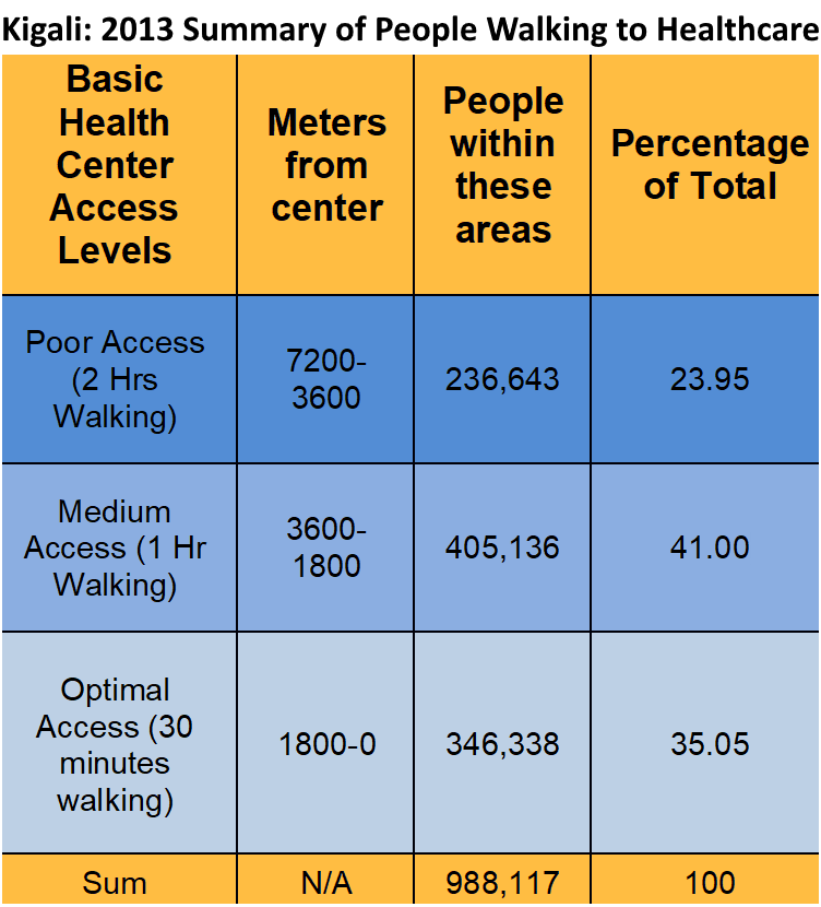
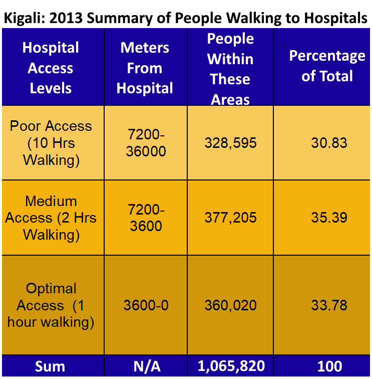
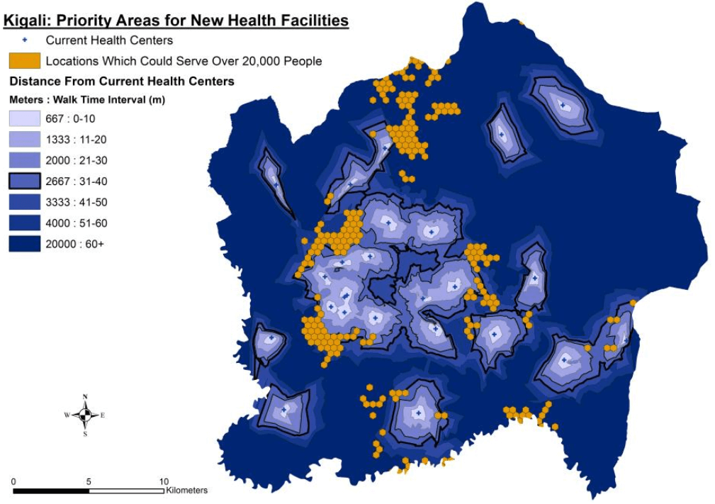
With over 23% of the city having to walk 2 hours to basic health clinics and over 30% having to walk 10 hours to a hospital we worked to identify locations with the opportunity to serve a minimum of 20,000 people. Choosing any of these locations for a new facility would directly impact over 20,000 people who'd prior had poor access to healthcare. By identifying these priority areas temporary services can target more vulnerable populations. These priority areas would also make excellent locations to setup emergency service stations in case of natural hazards. Knowing where to service vulnerable populations provides the basis of response recovery planning.
Available funds and resources are typically the largest constraint for building and staffing health facilities. A large city may need three hospitals, but can only afford one. This places an even higher importance on the density of smaller, more basic health clinics and certifying staff in the less dangerous procedures. Thus, GIS is largely used to find those suitable locations where current healthcare coverage is insufficient for the coming years.
Protecting Hospitals and Clinics: Anticipating and Planning Against Location Risks
Unfortunately, not every neighborhood is safe. GIS' spatial data assists the healthcare industry by identifying those neighborhood pockets prone to violent attacks. Locations with the potential for high crime or local government instability still need health services, but each building will require a fortified design to withstand armed assault and ease of security check-ins. Simple things as bulletproof glass, keypad locked doors, indoor gardens as a substitute of outdoor break rooms, and shared shuttles to and from work help retain qualified medical professionals and their staff who might otherwise relocate for fear the neighborhood isn't safe.
GIS and Remote Sensing are commonly used to identify risk and severity of a health facility's potential location. When assessing the damage done by the early 2000 earthquakes in the Eurasian countries one of the Structural Engineers working with us claimed, "It only takes a couple unfortunate things to happen at once to turn a hazardous event into a catastrophe." In this instance, it seemed the earthquakes were particularly catastrophic because they'd happened at night while people where sleeping and they severely damaged the local hospitals' ability to respond to the mass of injuries. Natural hazard events like earthquakes can escalate from disastrous to catastrophic scale if the city's healthcare services are disabled. Protecting our emergency service staff, their mode of transporting patients, and the healthcare buildings are essential for a city's recovery. Cities who loose essential services have much higher chance of high life loss, loss or relocation of skilled workers, future economic struggle, and increased difficulty rebuilding. To avoid this any particular natural risk must be considered and counteracted in the building design. With each risk analyzed for severity and frequency of occurrence the building codes can be updated and strengthened accordingly. It also identifies the level of insurance needed. Healthcare buildings in high-hazard areas must be insured, with higher financial priority, since there are such high consequences if the owner can't afford to repair the facility's damage.
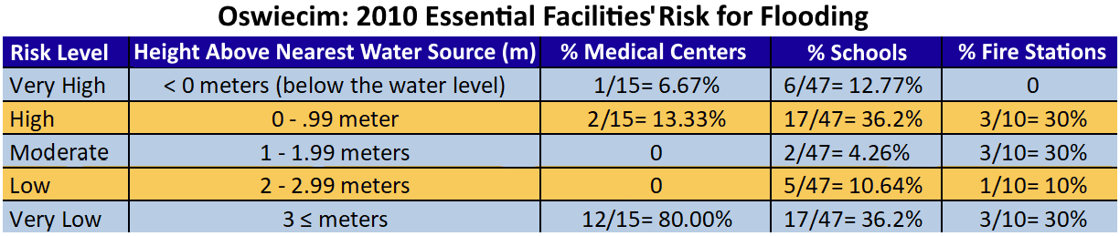
This case can be seen in the Polish municipality of Oswiecim, home of the historical site Auschwitz Concentration Camp, where 3 of their medical centers are in zones of high or very high risk of flooding. The same event in Oswiecim has the potential to damage and threaten other public services including 23 schools and 3 fire stations which are located in the same risk categories for their placement in elevation above the flooding river. An event to flood a single meter above the river's bank would escalate Oswiecim's state of emergency and significantly impair their community's ability to respond due to the combination of medical centers, schools, and hospitals inundated with water. The below data was collected by one of our analysts in 2010.
GIS & Spatial Data Improving Existing Healthcare Services
GIS is essential for any hospital EMS and ambulance services using routing software. All emergency service routing software requires road and address data. If your software or road data is outdated it could be the difference between saving and losing your patients, simply because your emergency service team didn't have adequate information. Setting up an automated service to update your database's road data is a quick and easy way to ensure your emergency services reach their destinations on time.
Healthcare outreach to certain populations, neighborhoods, and at-risk groups requires demographic data and an idea of where and how to contact them. This is where are targeted data collection and assessment helps administrations reach their healthcare clients. GIS and it's data help pinpoint the people who need you most. It assists in identifying what puts people in unhealthy conditions and helps healthcare teams reach those in need. It also creates trackable results for improving your citizens overall health, fitness, longevity, and livability by targeting neighborhoods for improvement. GIS assisted data showing your healthcare objectives and your outreach program's success are often submitted to win grants and national aid for your community.